
Go back to August 1953 with me. The team from the Stanford Research Institute (SRI) were about to present their findings for the ideal location of Disneyland to Walt and Roy Disney. Harrison “Buzz” Price was put in charge of the project, and with his brilliant mathematical mind, created a process that would narrow the vast Southern California region down to find the perfect location for Walt’s park. Walt paid the firm $25,000 for the location study. The only constraints were a minimum of 100 undeveloped acres at a price of no more than $4,500 per acre, preferably flat and with one owner. The ideal location would be somewhere between Chatsworth and Pomona on the north and Tustin and Balboa on the south. It should not be near the beach because Walt did not “want to attract the barefoot beach crowd.”

Price divided the region into ten geographically homogenous districts. Then he eliminated the districts that were already fully developed, were producing oil, suffered from a bad topographic feature, or were under governmental control. By doing this, he immediately eliminated eight out of the ten districts. One of the remaining districts was located in the Santa Ana Freeway corridor called the Whittier-Norwalk area, and the other was further south, in Orange County. SRI did a complete search of land records and looked at a variety of factors, including utility conditions, accessibility, topography, and environmental characteristics such as temperature, rainfall, and smog. The SRI team came up with a list of seventy-one possible sites within Los Angeles and Orange counties. They immediately eliminated twenty-eight sites because they were not within the Santa Ana Freeway corridor. The remaining forty-three sites were examined more closely using surveillance and local realtors. The best sites were further investigated by air. Walt visited twenty-four of the locations himself.
Of the remaining forty-three sites, ten were knocked off the list because of surrounding blight. Fourteen more were stricken from consideration because they were not for sale. Out of the nineteen remaining properties, four made the final cut for deeper analysis. Any of these four locations would have worked according to SRI. The remaining fifteen locations were put on the back burner and soon forgotten.
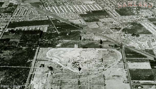
The site on the top of the list was the Ball Road Subdivision. It was adjacent to the city of Anaheim. It was also not on the original search list due to having multiple owners. Instead, the property came to the attention of SRI through a man named Fred Wallich. One of the families, the Dominguez family, did not mind selling some of their property but they wanted to keep one acre where the family home was located. This was only one of the problems with the site. More details will be found in the new book.
Another site was in La Mirada, and was made up of 5 parcels total 2,300-acres. Just think of what Walt could do with that much land. Known as the McNally Ranch, part of the property was slated to become single family homes and the rest was available for development. It would have cost more than Anaheim and it was not as close to the freeway. Today you can play a round of golf on the site.
The Leo Harvey property was on the boundary of Los Angeles and Orange counties near the intersection of Valley View Avenue and the Santa Ana Freeway. It was 650-acres and the owner wanted to sell 160 acres at the intersection of Miller Street (aka Valley View) and Orangethorpe. Today, the property is a giant warehouse.
The only site in Orange County was the Willowick Country Club just outside of Santa Ana. The lack of direct access to arterial highways was deemed a major fault.
And the rest, as they say, is history

Twitter – samlanddisneyFacebook – Sam GennaweyLinkedin – Sam Gennawey
You must be logged in to post a comment.